
Elevated sea surface temperatures across the Equatorial Pacific have prompted scientists to closely monitor the return of El Niño, one of the world’s most influential climate patterns. In June 2026, the U.S. National Oceanic and Atmospheric Administration (NOAA) officially declared the onset of El Niño after sea surface temperatures in the central and eastern equatorial Pacific remained at least 0.5°C above average for several consecutive months. New observations from NASA’s Sentinel-6 Michael Freilich satellite indicate that the event is continuing to strengthen, raising questions about its potential impacts on global weather, agriculture, water resources, and disaster preparedness in the months ahead.
NASA scientists are tracking more than just surface temperatures. Satellite measurements have revealed unusually high sea surface levels across parts of the Pacific Ocean, a key indicator that significant heat is building within the ocean system.
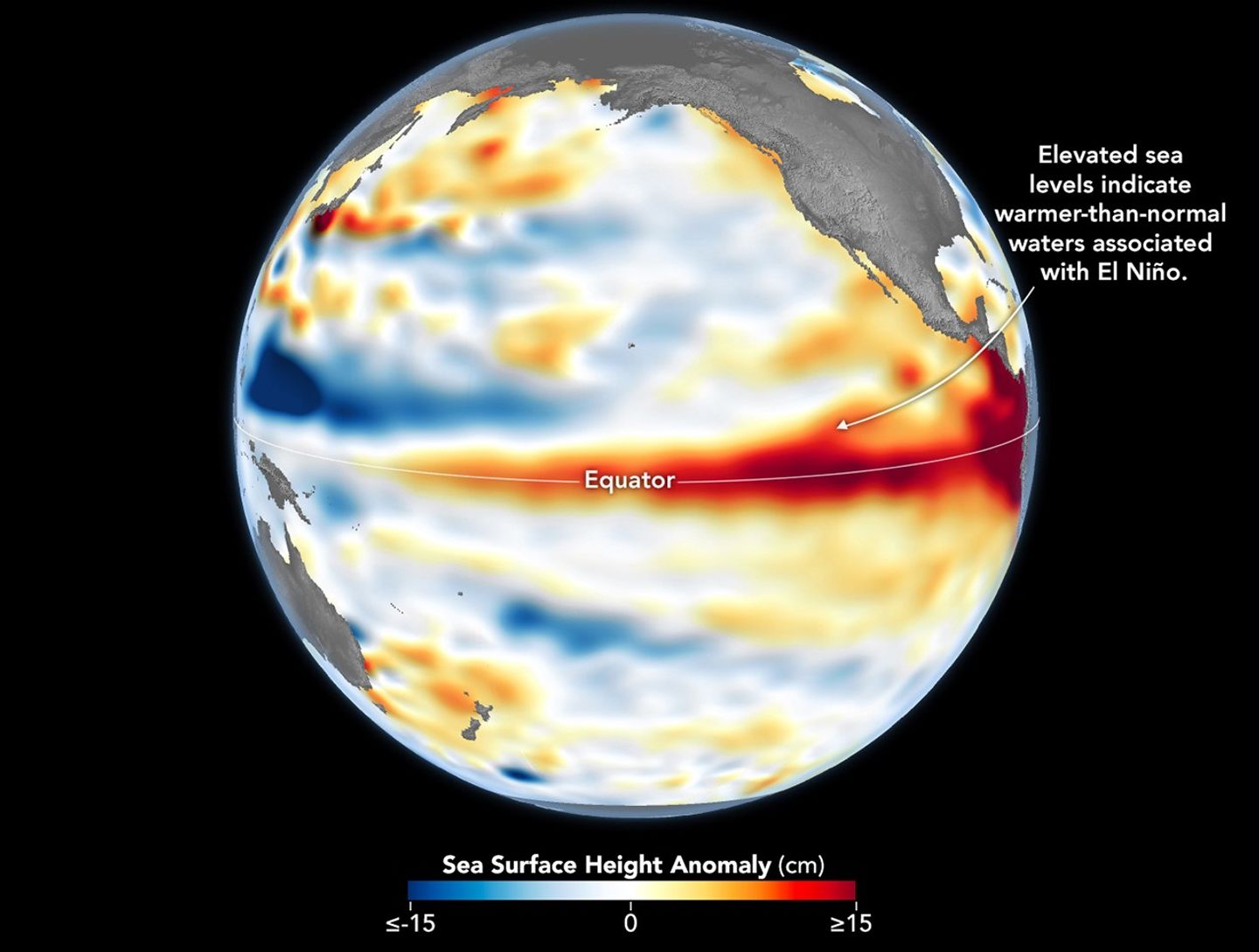
Source: NASA Earth Observatory / Lauren Dauphin
How NASA Is Monitoring El Niño
The Sentinel-6 Michael Freilich satellite, launched in 2020 by NASA and led by the European Space Agency (ESA), measures sea surface height with remarkable precision. When ocean water warms, it expands, causing sea levels to rise, and elevated sea surface height often signals warmer-than-normal ocean temperatures.
A NASA map from June 8, 2026, showed widespread areas of above-average sea surface height across the central and eastern Pacific. These observations provide valuable insights into how much heat is stored beneath the ocean surface, offering scientists a more complete picture than surface temperature measurements alone.
Key Indicators of the Developing El Niño
Indicator |
Observation |
|---|---|
NOAA El Niño Declaration |
June 11, 2026 |
Temperature Threshold |
At least 0.5°C above average |
Satellite Used |
Sentinel-6 Michael Freilich |
Key Ocean Signal |
Elevated sea surface height |
Climate Impact Regions |
Americas, Australia, Indonesia, Pacific Islands |
Also Read: US West Wildfires Intensify As Extreme Heat And Drought Grip The Region
The Role of Kelvin Waves
Before El Niño becomes fully established, scientists often detect large pulses of warm water known as Kelvin waves moving across the Pacific Ocean.
These waves can stretch hundreds of miles wide and transport warm water from the western Pacific toward the eastern Pacific. In spring 2026, Sentinel-6 detected several Kelvin waves as weakening trade winds allowed warm water to accumulate near the Americas.
- Kelvin waves help transport heat across the Pacific basin.
- They deepen the warm surface layer of the ocean.
- Reduced upwelling allows coastal waters to remain warmer than normal.
- Stronger Kelvin wave activity is often associated with strengthening El Niño conditions.
Also Read: China’s Export Controls On US Rare Earth Producers Raise Supply Chain Concerns
Similarities to the Historic 1997 El Niño
One of the most notable findings from NASA’s observations is the resemblance between current western Pacific conditions and those seen during 1997, a year that produced one of the strongest El Niño events on record.
According to NASA Jet Propulsion Laboratory sea level researcher Séverine Fournier, conditions observed in the western Pacific during June 2026 looked remarkably similar to those recorded during the early stages of the 1997 event. However, the eastern Pacific has not warmed as rapidly, and fewer Kelvin waves have developed compared to the same period in 1997.
Also Read: Extreme Heat Warnings Issued Across UK Ahead Of Potential 39°C Temperatures
What Could Happen Next?
Scientists emphasize that El Niño is still evolving. Additional warm Kelvin waves appear to be moving toward the eastern Pacific, suggesting that elevated sea surface temperatures across the Equatorial Pacific may continue increasing in the coming weeks.
Historically, El Niño can bring wetter conditions to the southwestern United States while increasing drought risks in Australia, Indonesia, and other parts of the western Pacific. The strength of the current event will ultimately depend on ocean-atmosphere interactions over the next several months.
For now, NASA’s satellite observations provide an important early warning system. By tracking both ocean temperatures and sea surface height, scientists can better understand how much heat is stored within the Pacific Ocean and how that energy may influence global weather patterns throughout 2026 and beyond.
Also Read: Scientists Decode Antarctica’s 30 To 50 Year Warning For Rising Seas

a temperatura media mensal na regiao do enso 3.4 é de 29,0 graus.. quais os valores medios das aguas sub superficiais a 10m, 100m e a 150m que pode se deslocal para leste atingindo o litoral od Equador e provocar ausencia de chuva na amazonia. Isso pode ocorrer?