
Nobody wakes up expecting a deluge, right? But for many in California, this past holiday week, flash flooding moved from distant forecast jargon to terrifying reality. In fact, the storms unleashed rainfall totals that in some places equaled nearly half of Los Angeles’s usual annual precipitation in just 72 hours, up to about 6 inches of rain in the greater Los Angeles area during this episode alone, overwhelming urban drains and scouring hillsides already vulnerable from earlier wildfires. California’s flash flooding turned streets into streams, hillsides into hazards, and ordinary weather systems into life-disrupting events.
So, what exactly drove these torrential downpours? Why did so much water fall so fast, and where was it all coming from? The causes are layered and complex, but deeply rooted in both big-scale atmospheric physics and local environmental conditions. This is a human story about water rushing where it should not become a flood.
Atmospheric Rivers Unleashed Moisture Over California

First and foremost, the culprit behind the heavy rains was a powerful atmospheric river. These are narrow corridors in the sky that act like rivers of water vapor hundreds of miles long, carrying moisture from the tropics directly toward the West Coast. Often dubbed the “Pineapple Express” when they draw moisture from around Hawaii, these storms can unload huge volumes of precipitation when they hit land and encounter cooler temperatures.
In this most recent setup, the atmospheric river that hit Southern and parts of Northern California carried dense moisture inland for days, and it dropped significant rainfall totals, in some mountain areas more than 12 inches in a very short span of time. In layperson’s terms, that means the sky was essentially pouring water as if someone had removed all the taps at once and turned them on full blast.
The science behind it is actually straightforward: air that can hold more water vapor travels from the warm Pacific into cooler continental air, the moisture condenses, and then gravity does the rest. What had been a dry surface suddenly became saturated and unable to absorb more water.
Also Read: Why Hurricane Flooding Is Set To Get Even More Dangerous In Florida
Recent Storm Data That Shows Just How Extreme the Rains Were
Let’s look at some of the rainfall data that illustrates just how much water California received due to California’s flash flooding crisis and how that stress translated into flash flood conditions. These figures come from official weather measurements during the recent event.
| Location | Rainfall Amount (Approx) | Duration |
|---|---|---|
| Los Angeles County | Up to 11 inches | Several days |
| San Gabriel Mountains (Wrightwood) | Around 12 inches | Three days |
| Greater LA Basin | 6 inches | 72 hours |
And this was just the rainfall totals. When you add in the speed at which rain fell in some areas more than 1 inch per hour, it helps explain why drainage systems, hillsides, and riverbanks were suddenly overwhelmed.
Also Read: Top 6 Most Expensive Climate Disasters Of 2025
Why Flash Flooding Happens So Fast
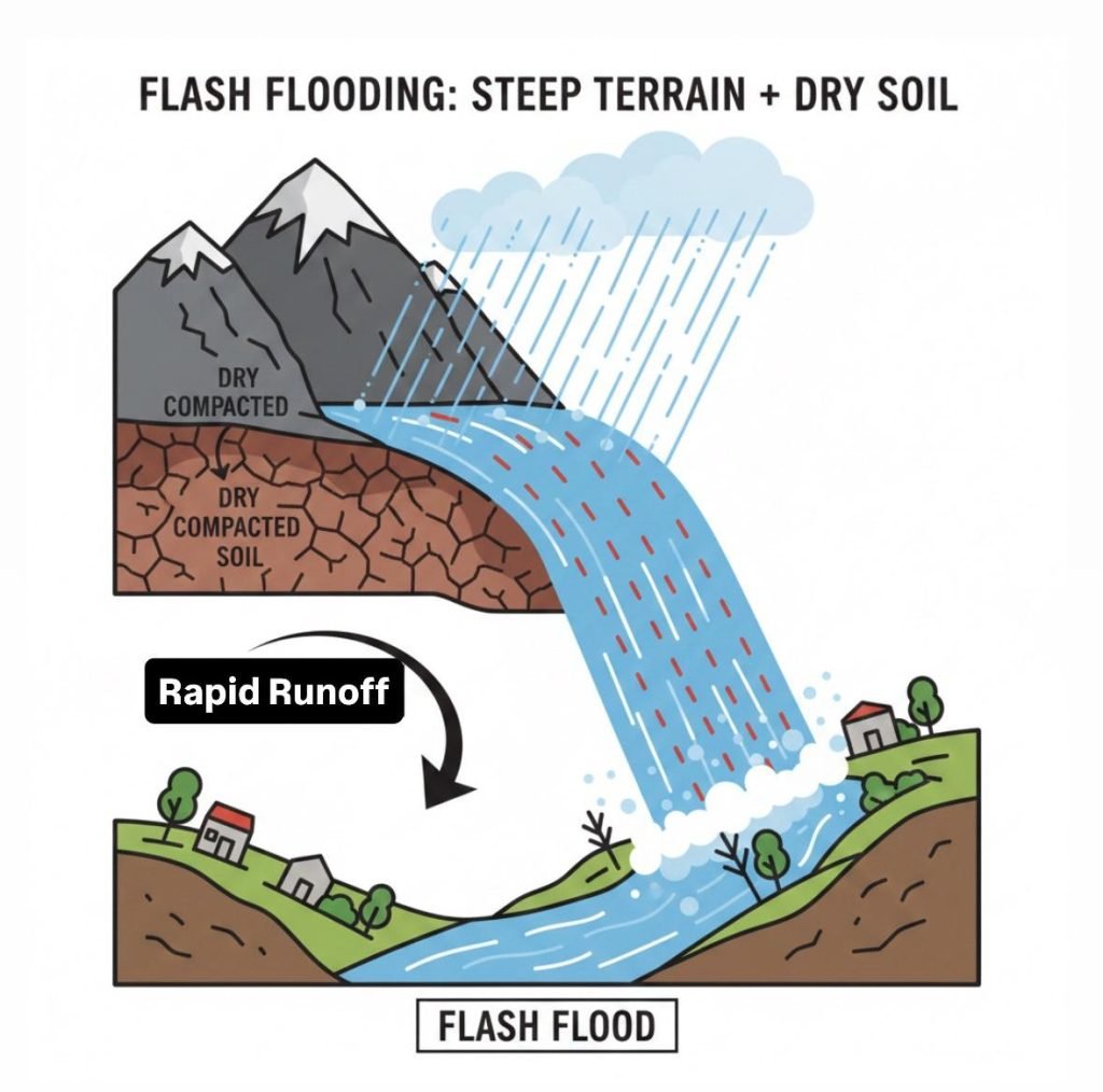
Even without considering climate trends, there is a natural vulnerability in many California landscapes to rapid flooding. Steep slopes in mountain zones cause water to rush downhill fast, and soils that go from dry to flooded in moments just cannot absorb incoming water. Add in years of drought that leave the ground parched and hard, and water slides on top like sheet metal, not into the earth.
Combine that with areas burned by wildfires earlier in the year, and the risk goes up even more. Vegetation that once helped hold soils in place was gone, leaving bare slopes that shed water quickly and magnified the flash flood and mudslide hazard. That meant communities near hillsides saw debris flows and mudslides that buried roads and trapped vehicles.
Also Read: COP30: CDRI Report Finds Disaster-Resilient Infrastructure Could Cut Economic Losses By 50%
The Human and Systemic Impacts of These Rains
What does it feel like when rivers form in places they never did before? Well, for many Californians, this was traumatic. In the mountain town of Wrightwood, roads turned into rivers of mud, homes and vehicles were damaged, more than 100 rescues were carried out, and evacuation orders were issued.
Travel during this storm was chaotic, with airports delaying or canceling flights when runways flooded, and regional power outages affected tens of thousands of customers. The Bay Area regions experienced landslides and trees downed by wind and saturated soils as far north as Santa Cruz County, which left people without electricity.
Tragically, these storms were deadly. At least three lives were lost in this episode from a combination of flooding and weather-related incidents.
These human costs remind anyone observing from afar that flash floods are far from abstract. They are events people live and die through, and families recover from for years.
Also Read: Stories Of Climate Solutions That Are Actually Working
Climate Change and the Bigger Pattern

So if atmospheric rivers are a natural part of California’s weather, why do these floods seem more intense lately? The science points strongly toward a warming climate intensifying the water cycle. Warmer oceans and air hold more moisture, and when conditions align, that extra water must come down somewhere.
Scientists have noted that atmospheric rivers can bring extreme precipitation that triggers flooding, and that a warmer atmosphere increases the potential for these intense rainfall events. Additionally, climate-driven trends point toward greater swings in weather, longer dry periods, and episodes with intense rainfall, which then contribute to extreme droughts and floods on the same landscape.
So while we cannot blame every single storm solely on climate change, the trend toward heavier precipitation when storms do occur is consistent with what climate scientists expect in a warming world.
Also Read: The Human Cost Of The Climate Crisis 2025 Analysis
What Comes Next
As the rains ease and the waters recede, another important phase begins: recovery and reflection. Communities will need to rebuild and repair infrastructure, reassess flood planning, and consider how to adapt to what meteorologists are calling a new normal of more frequent, intense storm events.
Emergency planners will also watch future atmospheric river forecasts closely because, frankly, California’s flash-flooding threat will not vanish as the rains stop. Wet winters still lie ahead, and the conditions that fed this episode: tough topography, parched soils, and a moister atmosphere – are still part of the picture.
Also Read: Saudi Arabia Records First Snowfall In 30 Years As Desert Climate Shifts
Frequently Asked Questions on California’s Flash-Flooding
1. What exactly triggered all the heavy rains behind California’s flash flooding
The primary trigger was a powerful atmospheric river that carried an extraordinary amount of moisture from the Pacific into California, dropping very high amounts of rainfall in a short period.
2. How much rain fell during the recent floods
Some locations received more than 11 inches of rain over a few days, and the greater Los Angeles basin saw up to 6 inches in 72 hours.
3. Why does California flood when it is often dry or drought-prone
Hard, dry soils, steep terrain, and loss of vegetation from wildfires contribute to water running off quickly rather than absorbing, causing flash floods.
4. Are these flash floods becoming more common
Evidence shows that extreme rainfall events are increasing in intensity with a changing climate, which can make floods more severe when storms occur.
5. What can communities do to reduce flood risk
Better flood planning, updated stormwater infrastructure, nature-based solutions like wetlands, and early warning systems can help manage future risks.
Also Read: New Study Highlights Urgent Climate Dangers Across The Arab Region

0 Comments